
I set out from a small harbour to the south of Grimstad, by the house where some of my colleagues are staying:

The weather is still rather cold, with plenty of snow and ice around:

I got some shelter from the wind by going through the harbour attached to this lighthouse:

An interesting looking piece of protected water could be seen but it was hard to find a way through:

No effort is spared to make paddlers from the UK feel at home. Most of the coast is very pleasant indeed but there are places to go if you are missing the North Wales coast:

I turned back to that interesting bit of protected water and tried to find somewhere to camp:

Sadly, the mainland was either waterlogged, rocky, covered in deep snow or a mess of low branches. I found a better site on the other side of the channel, on a tiny island:


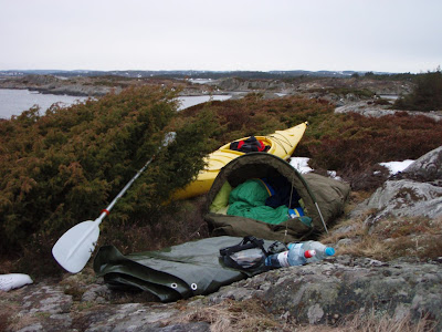
Carrying the laden boat up to the top was a bit of a struggle but I managed it:

This was the first outing for my hooped Goretex bivi in a long while:
 I set out from a small harbour to the south of Grimstad, by the house where some of my colleagues are staying:
 The weather is still rather cold, with plenty of snow and ice around:
 I got some shelter from the wind by going through the harbour attached to this lighthouse:
 An interesting looking piece of protected water could be seen but it was hard to find a way through:
 No effort is spared to make paddlers from the UK feel at home. Most of the coast is very pleasant indeed but there are places to go if you are missing the North Wales coast:
 I turned back to that interesting bit of protected water and tried to find somewhere to camp:
 Sadly, the mainland was either waterlogged, rocky, covered in deep snow or a mess of low branches. I found a better site on the other side of the channel, on a tiny island:

 Carrying the laden boat up to the top was a bit of a struggle but I managed it:
 This was the first outing for my hooped Goretex bivi in a long while:


